A powerful cyclonic weather system steered across the United States by the jet stream threatens fierce thunderstorms and ‘snow squalls’.
The Midwest, Central Great Lakes, the Ozarks and Ohio Valley are most at risk of severe weather this week amid warnings for ‘dangerous’ travel conditions.
The storm will sweep in from the west putting more than more than 12 States from California through Nevada, Utah, New Mexico and Arizona under a raft of National Weather Service (NOAA) alerts.
Up to a foot of snow is forecast in parts by Tuesday, with one to two inches falling within an hour, according to the NOAA.
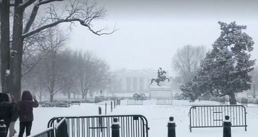
A spokesperson said: “A strong winter storm and cold front will move into the Northwest on Sunday and progress south-eastward into the Northern Rockies on Monday.
“Snow squalls are likely along the path of the cold front on Monday over the Northern Intermountain Region/Rockies, which could create a rapid drop in visibility and icing on roadways, leading to dangerous travel.
“By Tuesday, the moisture will produce showers and thunderstorms over parts of the Ohio Valley.”
Winter Storm Warnings are in force across Montana, Idaho, Colorado and Utah, while separate Winter Weather Advisories cover Nevada, California, Oregon and Washington.
US LATEST:- Joe Biden gaffe as President mixes up China and Russia in speech
- Neighbour left raging after homeowner refuses to move trees: ‘It's like a jungle!’
- Joe Biden lays bare candid sex confession as he shares 'secret' of lasting marriage to Jill
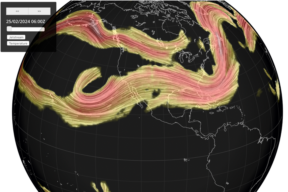
The storm is being swept across the United States by the jet stream which in a ‘zonal’ position is cutting straight through the country from the Pacific.
It will follow a cold front as it charges eastwards, pushing temperatures down and bringing heavy snow.
By Wednesday, the deluge will have reached Arkansas, Indiana and southern Michigan.
Weather Channel meteorologist Linda Lam said: “By later on Tuesday, there will be the presence of a risk of severe thunderstorms ahead of a cold front from the Ozarks into the Central Great Lakes ahead of a cold front.
“The low-pressure system will slide eastward on Wednesday, pushing the thunderstorm threat into portions of the Ohio Valley and South.
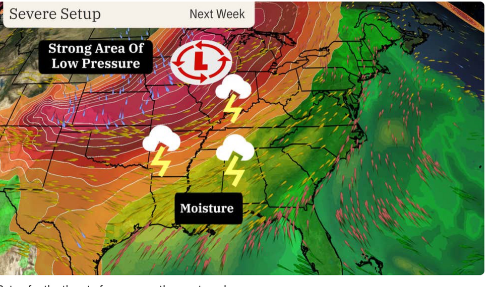
“The area stretches from northern Mississippi and northern Alabama northward into Tennessee and Kentucky Wednesday into early Thursday.”
Stormy conditions are being bolstered by a plume of warm air from the Gulf of Mexico hitting cold air further north.
While storms in the south are not uncommon for the time of year, they will move unseasonably north.
Ms Lam said: “Moisture will surge northwards from the Gulf of Mexico as abnormally warm temperatures arrive from the Plains to the East coast, ahead of this storm system.
“This will provide favourable ingredients for severe thunderstorms from late Tuesday, and although this threat is not unusual in the south in February, it isn’t so common farther north.
“However, given the record warmth expected next week ahead of this strong system, the potential for severe thunderstorms will extend farther north than is typical.”
The ‘battle’ between warm and cold air over the coming weeks threatens further storm activity, forecasters warn.
In addition, El Nino–a warming of ocean waters off the coast of Peru– starting to wane will drive the deluge.
Jim Dale, US weather correspondent and senior meteorologist for British Weather Services, said: “El Nino is weakening at the moment, but with the added factor of climate change, we are already seeing very high temperatures in parts of the US.
“Together with the weather synoptics, and when this hot air battles with colder air from the north, we get the perfect conditions for storms or even tornadoes.”
from GB News https://ift.tt/nwuXora
A powerful cyclonic weather system steered across the United States by the jet stream threatens fierce thunderstorms and ‘snow squalls’.
The Midwest, Central Great Lakes, the Ozarks and Ohio Valley are most at risk of severe weather this week amid warnings for ‘dangerous’ travel conditions.
The storm will sweep in from the west putting more than more than 12 States from California through Nevada, Utah, New Mexico and Arizona under a raft of National Weather Service (NOAA) alerts.
Up to a foot of snow is forecast in parts by Tuesday, with one to two inches falling within an hour, according to the NOAA.

A spokesperson said: “A strong winter storm and cold front will move into the Northwest on Sunday and progress south-eastward into the Northern Rockies on Monday.
“Snow squalls are likely along the path of the cold front on Monday over the Northern Intermountain Region/Rockies, which could create a rapid drop in visibility and icing on roadways, leading to dangerous travel.
“By Tuesday, the moisture will produce showers and thunderstorms over parts of the Ohio Valley.”
Winter Storm Warnings are in force across Montana, Idaho, Colorado and Utah, while separate Winter Weather Advisories cover Nevada, California, Oregon and Washington.
US LATEST:- Joe Biden gaffe as President mixes up China and Russia in speech
- Neighbour left raging after homeowner refuses to move trees: ‘It's like a jungle!’
- Joe Biden lays bare candid sex confession as he shares 'secret' of lasting marriage to Jill

The storm is being swept across the United States by the jet stream which in a ‘zonal’ position is cutting straight through the country from the Pacific.
It will follow a cold front as it charges eastwards, pushing temperatures down and bringing heavy snow.
By Wednesday, the deluge will have reached Arkansas, Indiana and southern Michigan.
Weather Channel meteorologist Linda Lam said: “By later on Tuesday, there will be the presence of a risk of severe thunderstorms ahead of a cold front from the Ozarks into the Central Great Lakes ahead of a cold front.
“The low-pressure system will slide eastward on Wednesday, pushing the thunderstorm threat into portions of the Ohio Valley and South.

“The area stretches from northern Mississippi and northern Alabama northward into Tennessee and Kentucky Wednesday into early Thursday.”
Stormy conditions are being bolstered by a plume of warm air from the Gulf of Mexico hitting cold air further north.
While storms in the south are not uncommon for the time of year, they will move unseasonably north.
Ms Lam said: “Moisture will surge northwards from the Gulf of Mexico as abnormally warm temperatures arrive from the Plains to the East coast, ahead of this storm system.
“This will provide favourable ingredients for severe thunderstorms from late Tuesday, and although this threat is not unusual in the south in February, it isn’t so common farther north.
“However, given the record warmth expected next week ahead of this strong system, the potential for severe thunderstorms will extend farther north than is typical.”
The ‘battle’ between warm and cold air over the coming weeks threatens further storm activity, forecasters warn.
In addition, El Nino–a warming of ocean waters off the coast of Peru– starting to wane will drive the deluge.
Jim Dale, US weather correspondent and senior meteorologist for British Weather Services, said: “El Nino is weakening at the moment, but with the added factor of climate change, we are already seeing very high temperatures in parts of the US.
“Together with the weather synoptics, and when this hot air battles with colder air from the north, we get the perfect conditions for storms or even tornadoes.”


0 Comments
Don't share any link